PROFESSIONAL DRAIN MAPPING & ASSET LOCATION SERVICES
Drain Mapping Services in Twickenham – Same Day Reports
Drain Mapping & Asset Location Services in Twickenham & South West London – 24/7 Drainage Engineers
Accurate, Reliable & Cost-Effective Drain Mapping Solutions for Homes & Businesses
Drain Mapping & Utility Location in Twickenham & Surrounding Areas
Knowing the exact location of underground drains, sewers, and utility lines is vital for both property owners and developers. Without accurate drain maps, projects can face costly delays, unexpected damage, and compliance issues.
At Drain Master UK, we specialise in drain mapping and asset location services across Twickenham, Kingston, Surbiton, Richmond, and throughout South West London. Using advanced technology such as CCTV drain surveys, sonde tracing, and ground-penetrating radar (GPR), we provide detailed mapping solutions for both residential and commercial clients.
Our services are essential for construction projects, property sales, renovations, and preventative maintenance, ensuring you have reliable drainage information before any works begin.
Why Choose Drain Master UK for Drain Mapping & Asset Location?
24/7 Availability
Whether you’re a homeowner, contractor, or property manager, our engineers provide fast and professional drain mapping services across South West London — available day or night.
Accurate & Compliant Surveys
We use industry-approved methods and equipment, adhering to Water Authority requirements, building regulations, and environmental standards. Our reports are clear, precise, and designed for planning applications, insurance, and legal compliance.
Transparent Pricing
With fixed, upfront quotes and no hidden fees, property owners and developers across Twickenham, Kingston, Surbiton, Richmond, Barnes, Teddington, Chiswick, Hampton, and Staines rely on us for cost-effective drain mapping solutions.

Our Drain Mapping & Asset Location Solutions
Accurate knowledge of your underground drainage and utility network is essential for safe construction, compliance, and long-term property management. At Drain Master UK, we provide expert drain mapping and asset location services that give homeowners, contractors, and developers a clear picture of their drainage systems before any work begins. Using the latest CCTV surveys, sonde tracing, and ground-penetrating radar (GPR), we deliver precise maps and reports that prevent costly mistakes, protect buried utilities, and ensure projects run smoothly across Twickenham, Kingston, Richmond, Surbiton, and throughout South West London.
CCTV Drain Surveys for Mapping
Our CCTV drain surveys use high-definition cameras to provide a crystal-clear view of your underground drainage system. By recording every section of your pipework, we can create precise drain maps that show layouts, connections, depths, and access points. This process not only supports property owners, contractors, and developers but also helps identify hidden defects, blockages, root ingress, or structural weaknesses before they escalate into major problems. CCTV mapping is an essential tool for planning applications, insurance claims, and compliance with local authority requirements.
LEARN MORE

Drain & Pipe Tracing
We employ sonde technology and ground-penetrating radar (GPR) to accurately trace the exact location and depth of drains and utilities without the need for invasive excavation. Our engineers track both plastic and metal pipework, ensuring precise results even in built-up or complex environments. This method prevents costly mistakes during building works, utility installations, or landscaping projects. Whether you need to locate sewer lines under a driveway or map out connections for a large commercial development, our drain tracing service ensures safe and efficient planning.
Utility Location Services
Our team specialises in utility mapping and asset location, accurately identifying and recording the position of sewers, stormwater drains, water supply pipes, gas lines, telecoms, and electrical conduits. This service is crucial for construction companies, architects, and local authorities needing accurate underground data before breaking ground. By preventing accidental strikes on hidden utilities, we save clients from expensive delays, repair costs, and compliance issues with the Health & Safety Executive (HSE) guidelines.


Asset Mapping Reports
Once surveys and tracing are complete, we compile the data into professional asset mapping reports. These include CAD drawings, schematics, and GPS coordinates, making them suitable for planning submissions, environmental compliance, and insurance documentation. Every report is designed to be clear, accurate, and easy to interpret, giving property owners and contractors confidence in the integrity of their drainage system. For larger developments, we can also supply digital mapping files that integrate directly with project planning software.
Domestic & Commercial Drain Mapping
We offer customised drain mapping solutions to suit every type of property:
- Residential homes & driveways – ideal for extensions, renovations, and new builds.
- Restaurants, retail units & offices – ensuring compliance and smooth operation of commercial premises.
- Schools, hospitals & care facilities – providing accurate maps for maintenance and emergency planning.
- Housing associations & construction developers – delivering large-scale drain and utility mapping for long-term projects.
Our flexible approach means whether you’re a homeowner needing peace of mind or a developer managing a large site, you’ll receive a tailored mapping service designed to reduce risks and keep your project on schedule.


Post-Survey Site Restoration
If excavation or site entry is required during mapping, our team ensures everything is fully reinstated once the work is complete. We carefully restore surfaces including tarmac, paving, concrete, turf, and landscaped areas so your property is left safe, level, and visually appealing. By combining professional mapping with expert reinstatement, we minimise disruption while delivering long-lasting results.
FAQs – Drain Mapping & Asset Location Services in Twickenham & South West London
Drain mapping provides accurate information about the location, route and condition of underground drains and utilities. It is essential for safe construction, planning approval, build-over agreements, and preventing accidental strikes during groundwork.
CCTV surveys assess internal pipe condition (defects, roots, cracks). Drain mapping combines CCTV with tracing (sonde/EM), GPS and depth readings to create accurate plans of routes, connections and levels. They are often delivered together for a complete picture.
We use high-definition CCTV, sonde tracing, electro-magnetic (EM) detection, and ground-penetrating radar (GPR). For metallic and non-metallic pipes we deploy transmitters and sondes to obtain route, depth and connection data with minimal disruption.
Typical horizontal accuracy is within site-appropriate tolerances for construction planning (often ±100–300 mm depending on conditions). Depths are recorded at key nodes (manholes, junctions, changes in direction/gradient). We can align to site grids or OS coordinates on request.
Yes. Using sondes inserted via access points and GPR/EM techniques, we accurately trace non-metallic pipes (uPVC, clay, concrete) and locate manholes, laterals and unknown connections.
You’ll receive a clear PDF report with annotated plans, depths, pipe sizes/materials, photos and CCTV findings. CAD (DWG/DXF), GIS (SHP/GeoJSON) and layered utility drawings are available. We can include GPS coordinates, manhole schedules and defect coding.
Most domestic reports are issued within 24–48 hours of the survey. Larger commercial sites or CAD/GIS deliverables typically complete within 3–5 working days depending on scale and data requirements.
Yes. We follow HSE HSG47 (“Avoiding Danger from Underground Services”) and can deliver utility mapping aligned with PAS 128 methodology when specified, helping de-risk excavations and satisfy CDM requirements.
Yes. We can locate and map foul and surface systems, septic tanks, soakaways, interceptors, and attenuation crates, including levels and connections where accessible.
Pricing depends on site size, access, number of manholes, tracing complexity and deliverables (PDF only vs CAD/GIS). We offer fixed, upfront quotes with no hidden extras after a short scoping call.
Most homes are completed in around half a day. Larger commercial or multi-block sites may require 1–2+ days depending on the number of access points and tracing required.
Yes — we’re available 24/7 for urgent tracing, mapping and utility location to support time-critical works and make sites safe.
Please ensure access to manholes/inspection chambers, clear parking for our van, and permission to enter relevant areas. If chambers are sealed or buried, tell us in advance so we can allow for lifting/reinstatement.
Mapping is typically non-invasive. Minimal lifting of existing chambers is required. Only in rare cases do we recommend small trial holes—if so, we’ll quote and fully reinstate surfaces after works.
Yes. We regularly schedule early-morning, evening or weekend visits for schools, healthcare sites and busy commercial premises.
For private land, no special permission is usually required. Works on, or affecting, public sewers/highways may require permits or build-over consent (e.g., Thames Water). We can advise and support the process.
Yes. We carry full public liability insurance and guarantee our reporting accuracy to the agreed scope. Documentation can be provided for your principal contractor or CDM file.
You own the deliverables we produce for your project. We can revisit to update drawings after alterations, extensions or new connections so your asset records stay current.
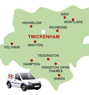
We cover Twickenham, Kingston, Surbiton, Richmond, Barnes, Teddington, Ealing, Chiswick, Hampton, Staines and wider South West London.

We provide our services to

Homes

Restaurants

Shops

Schools

Pubs

Gyms

Book Professional Drain Mapping in Twickenham Today
24/7 Drain Mapping & Utility Location – Residential & Commercial
Need accurate drain mapping or underground asset location in South West London? Call Drain Master UK today on 0208 893 9505 for expert service you can trust. We cover Twickenham, Kingston, Surbiton, Richmond, Barnes, Teddington, Ealing, Chiswick, Hampton, Staines, and surrounding areas.
Areas We Cover
We provide professional drain mapping & asset location services across South West London, including TW1–TW20, W1–W14, KT1–KT24, SW13–SW15.
Our local engineers are highly experienced and fully equipped to carry out everything from small domestic drain mapping to large-scale commercial asset location and complex utility tracing projects.
By choosing Drain Master UK, you’ll benefit from:
✅ 30+ years of expertise in drain mapping & utility location services
✅ 24/7 availability for urgent mapping & tracing callouts
✅ Accurate, safe, and non-invasive mapping methods using CCTV, GPR & sonde technology
✅ Clear reports, CAD drawings & transparent pricing with no hidden extras
Contact Drain Master UK today for trusted, safe, and fully guaranteed drain mapping & utility location services — keeping your property and projects compliant, safe, and protected 24/7.
Your Reliable Solution for Drainage Needs!
Simply leave your details with us and we will get back to you!
If you have any questions,
would like advice or simply like a free quote, Call Today on
Phone: 0208 893 9505 or Mobile: 07956 110288

